| XXX |
| XXX |
| Published in 1475, the illustrated world history, Rudimentum Novitiorum, included two remarkable maps - one of Palestine and this one of the world. “These are the first printed maps to try and show land forms and countries in topographical relation to each other. The world map derives from a Christianised medieval tradition without any reference to either Ptolemaic or portolan sources, and is avivid piece of early cartographical design” -- Shirley. The Rudimentum Novitiorum would go on to become more widely known through later French translations under the title Mer des Hystoires. Over 100 places-names and geographic features are identified, with towns and countries named. Each country is represented as a separate hill accompanied by either a figure of the sovereign or sever-al small buildings representing towns. Many of the hills are surrounded by water, and there are numerous trees, buildings, historical and religious figures scattered throughout. “It is unlikely that the map-maker intended his readers to treat too literally the relationship of distance and direction between one country and another,” according to Tony Campbell, “Crete and Cyprus, for example, are shown to thenortheast of France and Rome is to the south of it.” Nevertheless, this remarkable map provides us with one of the earliest, and certainly the most complete, depictions of Europe’s medieval conception of the world. www.arkway.com/pfds/Cat54.pdf |

| If you have a picture you'd like us to feature a picture in a future quiz, please email it to us at CFitzp@aol.com. If we use it, you will receive a free analysis of your picture. You will also receive a free Forensic Genealogy CD or a 10% discount towards the purchase of the Forensic Genealogy book. |


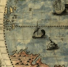
| Atlantic Islands too big and misplaced. |
| ********** |
| ********** |

| If you enjoy our quizzes, don't forget to order our books! Click here. |
| Quiz #326 Results |
| Answers: 1. Paolo Forlani in 1564 2. Because Australia is missing. It was first sighted in 1606 by Dutch explorers. 3. Lots: Australia is missing The west coast of North America is connected to Asia Antarctica is too large and those animals don't live there. Greenland and Iceland are misplaced. The Rocky Mountains are not in a straight line. South America is not attached to the Antarctic continent. and more... |
| ********** |
1. Who created this map? 2. How can you tell it was created before about 1606? 3. Name three geographical mistakes it contains. |
| Answers to Quiz #326 October 16, 2011 |
| Tin Eye Alert! You can find this photograph on TinEye, but you will have more fun if you solve the puzzle on your own. |
| Congratulations to Our Winners Joshua Kreitzer Colliier Smith Robert W. Steinmann Jr. Diane Burkett Nicole Blank Angel Esparza Betty Chambers Daniel E. Jolley Donna Jolley Margaret Waterman John Fitzpatrick Carol Farrant Dennis Brann Kelly Fetherlin Don Draper Margaret Paxton Shirley Hamblin Arthur Hartwell Barbara Mroz |
| Comments from Our Readers |
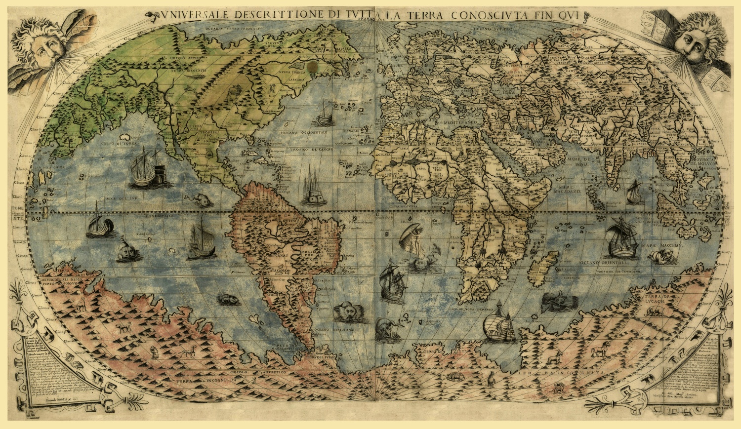
This “universal description of the known world” was created by Italian engraver/map
maker, Paolo Forlani in 1565. I found the images of ships and sea life very intriguing.
They help to make this world map a work of art. To find proof that the map was done
before 1606 I did searches for world events in 1606. One that stood out was the initial
exploration of Australia in 1606, by the Dutch navigator, Willem Janszoon. I think if the
map had been produced after that year the continent of Australia would be shown.
There are many imperfections on the map compared with what we know today. Europe
and Africa seem to be amazingly accurate. We can tell that North America is indeed the
“New World”. Some things that the cartographers needed to correct were:
1. Realize that Antarctica was not as large as is shown on this map and that some of the
mammals depicted there could not survive.
2. Exploration of the Pacific Ocean between Asia and North America. Here the two
continents are connected from what are now Alaska and California which of course is
not true.
3. 71% of the earth is made up of ocean water, but on this map it appears that land is
closer to that percentage.
I did not need Tin Eye to solve this quiz but it was interesting to check it out after
knowing the answers. Many of the sites showing the map were selling prints.
Don Draper
*****
He forgot to put mermaids in the Atlantic Ocean area!!!! Dennis Brann
*****
Method:
I google-imaged "ancient world maps universale descrittione" and your
map was right near the top. http://tiny.cc/y662f gives a good version, but http://tiny.
cc/y662f gives the details of mapmaker's name, year, etc.
And http://bluemonocle.com/Maps/Product?itemCode=15327 will sell you versions to
frame on paper or canvas in various sizes and prices from $28 (11"x19") to $93 (22"
x37").
I am a map freak myself, with dozens of topos of Colorado, road maps of almost every
state, and many Nat'l Geographic maps from the last 50 years or so. I can sit and read
a map for hours sometimes, if it's a good one....
The mistakes are innumerable, but some of the largest are the ones I listed;
aside from Australia, the others are just from elementary geography. Collier Smith
*****
After several fruitless searches, the search that got me to the answer was the
title on the top of the map, “Vniversale Descrittione di Tvtta la Terra
Conoscivta Fin Qvi”. Carol Farrant
*****
The photo featured in this week's photo quiz is a picture of an 1546 map by Giacomo
Gastaldi. The original would have been printed by means of carved wooden plate
printing, however this map was printed from a copper plate, engraved by Paolo Forlani
in 1565. The copper plate printing process produced much finer lines and details.
Kelly Fetherlin
*****
Thanks! This was fun :o) John Fitzpatrick
| ********** |
| ********** |
Paolo Forlani was the leading Italian mapmaker of the 1560’s,one of the greatest
decades in the history of cartography. Between 1560 and 1570 he issued four world
maps, this one from 1560 being the most majestic.
Almost 450 years old, it is stored at Library and Archives Canada in a national map
collection that includes many of the earliest records of North American geography.
What makes this map particularly significant is that it represents the first time Canada’s
name appears in print form. Until the printing of Forlani’s map, the name Canada had
only appeared in some manuscript depictions that were unavailable to the public. The
Forlani map was created only a few decades after Jacques Cartier’s historic voyages in
1534 and 1535 up the Saint Lawrence River. The map indicates that Canada is situated
in the exact location occupied by Quebec City to-day. It also cites the Arctic Ocean
(“Oceano Settentrionale”), “Tiera de Laborador,” “Stadacone” (the Iroquois settlement
at the future Quebec City), and “Saguenai.”
This beautifully executed map of the world is a prime example of the Italian printing
style, and shows a vast land covering the southernmost region of the world. The
continent at the South Pole was still only hypothesized in the 16th century, and this map
shows the conception at that time was of a land far larger and extending much further
north than in reality. The land at the South Pole is populated with both real and mythical
creatures, including an elephant, camel, unicorn, and griffin, among others. The seas
are full of sailing vessels and fanciful sea creatures. The map also shows the western
part of North America connected directly to Asia.
Forlani’s large world map was published in 1565, the year before Venice would reach
the “zenith of map engraving”. The map is based on Gastaldi’s landmark world map of
1542,despite Gastaldi’s having later pioneered the idea of separate Asian and American
continents with the addition of the Strait of Anian in 1562. Forlani here disregards this
advance and returns to the earlier model with North America joined to Asia.
Typical of the maps of this era, Forlani included images of various types of sailing ships
and unusual sea creatures in the Atlantic Ocean. The coastline features however
compare accurately with modern maps, proof of the fact that Forlani knew how to
incorporate knowledge about North America’s physical form from navigation charts
and explorers’ descriptions. Since Forlani was a commercial printer who re-inked his
plates on demand, the exact number of prints made of this map is unknown, adding an
element of mystery to this treasure.
http://tiny.cc/pqn9b
www.arkway.com/pfds/Cat54.pdf
Paolo Forlani (fl. mid-sixteenth century). Untitled world map in Antoine Lafrery’s
(1512–1577) Geografia tavole moderne di geographia (Modern geography of the greater
part of the world). Rome: Antoine Lafrery, 1575?. Published by Giovanni Camocio.
Geography and Map Division, Library of Congress (149.01.00)
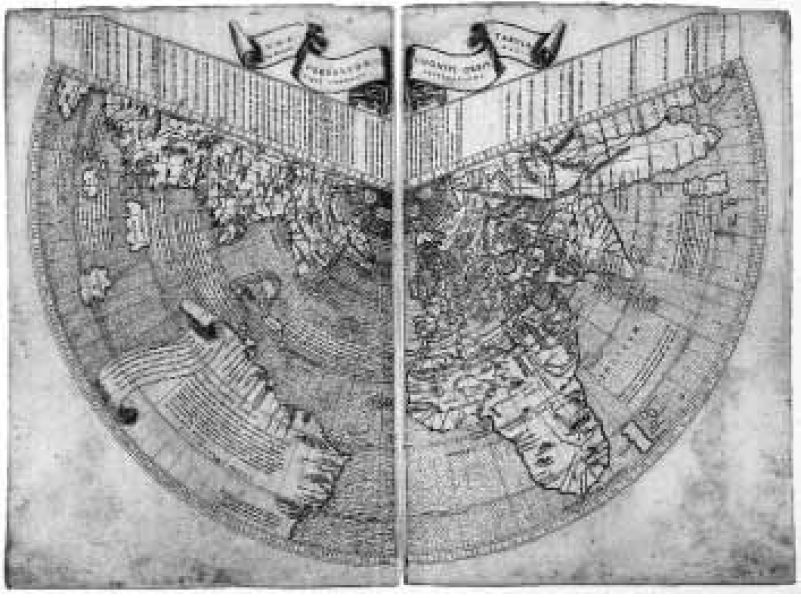
Paolo Forlani’s 1560 world map appeared fourteen years after the first appearance of
Italian cartographer Giacomo Gastaldi’s prototype world map. It is one of the earliest
maps of the world. The continent at the South Pole was still only hypothesized in the
16th century, and this map surprisingly shows a land mass of more or less the correct
size and shape. Later maps of the world by Forlani would greatly enlarge this land mass
(see his 1565 world map below for an example). The map includes the first naming of
Canada and Saguenai; the North American land mass is still shown joined to Asia. The
map includes two multi-pointed compasses, numerous sea monsters, Venetian galleys,
and other ships in the sea.
http://tiny.cc/6s5qc
(1512–1577) Geografia tavole moderne di geographia (Modern geography of the greater
part of the world). Rome: Antoine Lafrery, 1575?. Published by Giovanni Camocio.
Geography and Map Division, Library of Congress (149.01.00)
Paolo Forlani’s 1560 world map appeared fourteen years after the first appearance of
Italian cartographer Giacomo Gastaldi’s prototype world map. It is one of the earliest
maps of the world. The continent at the South Pole was still only hypothesized in the
16th century, and this map surprisingly shows a land mass of more or less the correct
size and shape. Later maps of the world by Forlani would greatly enlarge this land mass
(see his 1565 world map below for an example). The map includes the first naming of
Canada and Saguenai; the North American land mass is still shown joined to Asia. The
map includes two multi-pointed compasses, numerous sea monsters, Venetian galleys,
and other ships in the sea.
http://tiny.cc/6s5qc

Gastaldi's Map of Moscovia
(1550)Giacomo Gastaldi (Villafranca
Piemonte c. 1500 - Venice, October 1566)
was an Italian cartographer of the 16th
century. Gastaldi (sometimes referred to as
Jacopo or Iacobo) began his career as an
engineer, serving the Venetian Republic in
that capacity until the fourth decade of the
sixteenth century. From about 1544 he
turned his attention entirely to mapmaking,


| Universale Descrittione di Tutta la Terra Conosciuta Fin Qui Complete description of the Earth as We Know It |
| 1565 Language: Italian Creator: Paolo Forlani http://bluemonocle.com/Maps/Product?itemCode=15327 |
| ********** |
| Paolo Forlani's Earlier 1560 Map |
| 1560 Language: Italian Creator: Paolo Forlani http://bluemonocle.com/Maps/Product?itemCode=15346 |
| South America appears to be joined to Antarctica. The Amazon River is too long. |
| North America is joined to Asia. |
| Australia is missing. |
| Greenland and Iceland are too far north and misplaced. |
| ********** |
| ********** |
| Take a better look at the strange sea and land creatures. I've only identified two - the unicorn and the griffin. |


| On the land... |
| In the sea... |
| Antarctic Griffin |
| Antarctic Unicorn |
| ********** |
| Giacomo Gastaldi en.wikipedia.org/wiki/Giacomo_Castaldi |
| Gastaldi's Map of Moscovia (1550) |
and his work represents several important turning points in cartographic development.
According to the author Philip Burden, Gastaldi’s 1548 edition of Ptolemy's Geography
"was the most comprehensive atlas produced between Martin Waldseemüller's
Geographia of 1513, and the Abraham Ortelius Theatrum of 1570,” because it included
regional maps of the Americas. Yet Gastaldi’s detailed attention to the new world was
not his only contribution to the development of map production. The Ptolemy edition of
1548 was also an innovation in that Gastaldi and his publisher reduced the size of the
volume, thereby making the first ‘pocket’ atlas. Finally, Gastaldi’s work also indicated a
shift in cartographical technique via its use of the copper engraving. Prior to this period,
most maps had been printed from woodcuts; by using a copper plate rather than a
woodblock to print, the engraver could render a much higher level of finesse and detail]
Gastaldi was described by one contemporary as the ‘most excellent Piedmontese
cosmographer.' As a cartographer, Gastaldi worked for various publishers, such as
Nicolo Bascarini and Giovanbattista Pedrezano. But he also occasionally accepted
private commissions, for example that from Venice’s Council of Ten, who invited him
to fresco maps of Asia and Africa on the walls of a room in the Doge's Palace.
Among his other works is the Asiae Nova Descriptio, engraved in copper in 1574.
Further information about Gastaldi is available from the antique map dealers, Leen
Helmink.

| Rudimentum Novitiorum Anonymous Lubeck, Germany 1475 Circular woodcut map 14 3/4” in diameter. On two half-sheets as printed. |
| Johann Ruysch’s 1507 map of the world is one of the true epoch- making works in the history of cartography. With the exception of the 1506 Contarini-Rosselli map, known only in a single example, the Ruysch is the earliest printed map to show America. Compared to the accepted Ptolemaic world view of the time, the Ruysch is nothing less than revolutionary. Suddenly the size of the known surface of the earth more than doubles. Ruysch introduces the Atlantic Ocean and centers the map in such a way that the entire left sheet represents newly discovered areas. Engraved on a fan-shaped conical projection, the Ruysch map depicts the wave of geographical discoveries flooding Europeans at the time. Of immediate impact, the appearance of part of the Southern Hemisphere and the West Indian Islands endorse Columbus’ view that these new territories were off the Asian mainland. Greenland has been disconnected from Europe and newly connected to Asia. In a note, Ruysch speculates that Spagnola [Hispaniola] is probably Spangu [Japan] as reported by Marco Polo. Cuba is greatly enlarged but cut off by a scroll stating that the Spanish hadn’t completed their exploration of the area - indicating that Ruysch relied more on Portuguese than Spanish sources. It is also the earliest map to show the polar regions with anything approaching accuracy and the first to show the result of exploration of the coast of Brazil. In spite of the enormous amount of information on the New World, the Ruysch map concerns itself just as seriously with discoveries to the east, and there are equally significant improvements in the mapping of Africa, India and eastern Asia. The map is extremely rare. www.arkway.com/pfds/Cat54.pdf |
| Universalior Cogniti Orbis Tabula Ex Recentibus Confecta Observationibus Johann Ruysch Rome, 1507 16” x 21 3/4”. On two half-sheets as issued. Uncolored. |
| XXX |
| Two years after Gastaldi’s landmark map of the world of 1546, he published this much smaller ver-sion for the first compact edition of Ptolemy - the Geographiaof 1548. The 1546 Gastaldi was the ear-liest in the series of world maps by Italian engravers published in LaFreri atlases and one of the mostimportant maps of the sixteenth century. On both maps, North America is joined to Asia along nearlyits entire length. Some years later, Gastaldi would be the first mapmaker to make separate continentsof Asia and America by creating the Straits of Anian. North and South America are linked on the mapby a narrow isthmus. The 1546 Gastaldi is an unobtainable rarity, making this 1548 version one of the earliest obtain-able examples of Italian cartography from its greatest period in map-making. www.arkway.com/pfds/Cat54.pdf |

| Universale Nova Giacomo Gastaldi Venice 1548 5 1/4” x 7”. Uncolored. |
| XXX |
| Gerard Mercator’s revolutionary map of 1538 is chiefly known from this close copy by the Roman publisher Antonio Salamanca. The Mercator original, his first map of the world, survives in only two complete examples. “[Salamanca’s] undated copper-plate engraving is an excellent one, with stippled sea in place of the shading used by Mercator. The Mercator was the first influential printed map to definitively separate the New World discoveries from the Asian mainland. North America assumed, for the first time, continental proportions. It was also here that North and South America were first unambiguously joined and the name America used to encompass both landmasses. This is a thoroughly modern image of the world, which rejects altogether the lingering Ptolemaic conceptions. Here is the beginning of the mapping of North America. www.arkway.com/pfds/Cat54.pdf |
| Ant. Sal Exc.:Romae Antonio Salamanca Rome, c 1550-1564 13” x 20 1/4”. Uncolored. |

| XXX |
| For more great maps of the Middle Ages and the Renaissance era, check out RICHARDB. ARKWAY, INC. FINE ANTIQUE MAPS, ATLASES, GLOBES AND VOYAGE BOOKS CATALOG 54 WORLD MAPS C.1200 - 1700 59 EAST 54TH STREET, #62 • NEW YORK, NY 10022 (212) 751-8135 • (800) 453-0045 •FAX:(212) 832-5389 Click here to open catalog in pdf format. |