g
World Atlas World Time Zones Map and explanations
World Time Zones

The current GMT (Greenwich Mean Time) in Greenwich, England, is shown directly below, and that
time zone is indicated with a O (in the olive green square) at the bottom of the map. Greenwich is indicated with a white dot.
The numbers shown in each time zone (left or right) of GMT indicate the number of hours
you should add or subtract to find the current time in your area of interest.
As an example, note that California, on the western coast of the United States, is indicated as being -8. To easily determine the current time in California, simply subtract 8 hours from the GMT time shown directly below.
|
Irregular Time Zones
Some governments make local time zones decisions that deviate from the norm. Note that India is +5½ from GMT, while Myanmar (Burma) is +6½, Iran is +4½, Iraq is +3½, Nepal is +5¾ and Central Australia is +9½. The Canadian island of Newfoundland is -3½ hours from GMT, some smaller islands in French Polynesia are -9½, while the Pitcairn Islands are -8½.
|
Quiz #194
January 25, 2009
Gone but Not Forgotten
|
World Atlas, International Date Line map and explanation
|
time and date in
Fiji
|
|
|
|
time and date in
Tonga
|
|
|
|
time and date in
Samoa
|
|
|
|
time and date in
Hawaii
|
All these date line changes and calendar changes are pretty much like daylight savings
time now: it may confuse the farmers, but the chickens really don't care.
Charles F. Coates
*****
I love the fact that if you fly from Samoa to Tonga it takes approximately 2 hrs., but
you get there the day before you left! Thanks for helping to keep my brain alert.
Dennis Brann
*****
Sunday, November 18, 1883, also called "The Day of Two Noons", when each railroad station
clock was reset as standard-time noon was reached within each time
zone. Judy Pfaff
*****
As with photos and forensic evidence there is a timeline. It is a bit confusing for
travelers crossing timelines, dealing with the real time of day, solar time (height of
sun)government times and local times. So here is a timeline.
UTC (Universal Coordinated Time) or GMT Greenwich Mean Time:
12:01 pm Pacific Standard Time, July 5, 2009:
In American Samoa - Sunday, 08:01 am July 5, 2009
In Kiribaki and Western Samoa - 08:01 am UTC/GM Monday, July 6, 2009.
In England - 8:01 pm Sunday July 5, 2009.
Far to the North in the Bering Sea Straits passes the International Dateline between the
territories of two world powers between 2 Islands of Diomedes, separated by a mere
nautical mile -- Russia and the United States, within easy visual sight of another. No
you cannot see Russia from Wasilla, Alaska, which is several hundred miles to the West
and right. Mike Dalton
*****
Just think...if you lived on the border of the IDL...you could do something naughty on
one day...walk a few feet..and you'd be in tomorrow/yesterday and you could say what
ever happened didn't...man could I have used a place like this is high school!!!!
Rick Mackinney
*****
In 1949, the People's Republic of China was placed under one time zone, changing
from the previous five time zones it was under. Janice Sellars
*****
"Ti-i-i-ime is on my side, yes it is!" Marilyn Hamill
*****
The time zone changes from EDT to CDT just about 20 miles west of Knoxville. I
recall a newspaper article a number of years ago about people who worked or attended
school in one time zone and lived in the other and how they tried to accomodate the
differences into their everyday life. A problem, but not quite as difficult as trying to
adjust to an entire day's difference. Diane Burkett
The IDL Moves to the East of Samoa
July 4, 1892
|
In practice, there are two International Date Lines, the
de facto IDL and the de jure IDL.
The IDL drawn on all is now and always has been an
artificial construct of cartographers—it is de facto. No
international organization nor any treaty between
nations has fixed the "straight line" segments and their
junctions. All nations unilaterally determine their
standard time zones, which are applicable only on land
and adjacent territorial waters. These national zones do
not extend into international waters. These national
zones do not extend into international waters. Indeed,
the 1884 International Meridian Conference explicitly
refused to propose or agree to any time zones, stating
that they were outside its purview. The conference
resolved that the Universal Day (midnight-to-midnight
Greenwich Mean Time), which it did agree to, "shall
not interfere with the use of local or standard time
where desirable".
The nautical date line is a de jure construction
determined by international agreement. It is the result
of the 1917 Anglo-French Conference on Time-
keeping at Sea, which recommended that all ships,
both military and civilian, adopt hourly standard time
zones on the high seas. The United States, for
example, adopted its recommendation for US military
and merchant marine ships in 1920. This date line is
implied but not explicitly drawn on time zone maps. It
follows the 180° meridian except where it is
interrupted by territorial waters adjacent to land,
forming gaps—it is a pole-to-pole dashed line. Ships
must adopt the standard time of a country if they are
3. January 1, 1995,
when the Republic of
Kiribati moved the
Line so that the
western and eastern
parts of the republic
would have the same
date.
De Facto and De Jure International Date Lines
|
The Discovery of the Celendrical Date Line
|
Plotting the Globe:
Stories of Meridians,
Parallels, and the
International Date
Line
by
Nora Ariel Berger
Greenwood
Publishing Group, Inc
December 2005
ISBN-13:
9780275988951
|
Samoa changed the International Date Line in 1892, eight years following the 1884
International Meridian Conference that resulted in de facto development of the Date
Line. The king was persuaded by American traders to adopt the American date, being
three hours behind California, to replace the former Asian date, being four hours ahead
of Japan. The change was made at the end of the day on Monday, 4 July 1892, so there
were 367 days (1892 being a leap year), including two occurrences of Monday, 4 July.
The central Pacific Republic of Kiribati introduced a change of date for its eastern half
on 1 January 1995, from time zones −11 and −10 to +13 and +14. Before this, the
country was divided by the date line. This meant that the date line in effect moved
eastwards to go around this country. As a British colony, Kiribati was centered in the
Gilbert Islands, just west of the old date line. Upon independence in 1979, the new
republic acquired the Phoenix and Line Islands from the United States and the country
found itself straddling the date line. Government offices on opposite sides of the line
within its territorial waters, but must revert to international time zones (15° wide
pole-to-pole gores) as soon as they leave its territorial waters. In reality they use these
time zones only for radio communication etc. Internally in the ship, e.g. for work and
meal hours they use a suitable time zone of their own wish. The 15° gore that is offset
from UTC by twelve hours is bisected by the nautical date line into two 7.5° gores that
differ from UTC by ±12 hours. http://en.wikipedia.org/wiki/International_Date_Line
The International Date Line sits on the 180º line of longitude in the middle of the Pacific
Ocean, and is the imaginary line that separates two consecutive calendar days. It is not
a perfectly straight line and has been moved slightly over the years to accommodate the
time and date needs of varied countries in the Pacific Ocean. In the Eastern
Hemisphere, left of the International Date Line (the date) is always one day ahead of the
date (or day) in the Western Hemisphere.
The planet is divided into 24 time zones and there must be a place where a day begins,
thus the International Date Line. Travel west across it (gain a day), travel east across it
(lose a day).
Without the International Date Line travelers going westward would discover that when
they returned home, one day more than they thought had passed, even though they had
kept careful tally of the days. This first happened to Magellan's crew after the first
circumnavigation of the globe. Likewise, a person traveling eastward would find that
one fewer days had elapsed than he had recorded, as happened to Phileas Fogg in
"Around the World in Eighty Days" by Jules Verne.
The International Date Line can be anywhere on the globe. But it is most convenient to
be 180° away from the defining meridian that goes through Greenwich, England. It also
is fortunate that this area is covered, mainly, by empty ocean. However, there have
always been zigs and zags in it to allow for local circumstances.
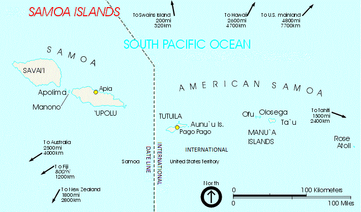
On the time and date codes shown below, note that Tonga and Samoa have the same
time but are (1) day apart, as Samoa is in the Western Hemisphere, on the opposite side
of the International Dateline from Tonga. As you travel further west, note that the time
in Fiji is (1) hour earlier than Tonga. You will also notice that Hawaii, further to the east
of Samoa, is (1) hour later in time.

Barrameda in September 1519, nearly three years later sighted the Cape
Verde Islands, he noted:
“On Wednesday, the ninth of July [1522], we arrived at one these islands
named Santiago, where we immediately sent the boat ashore to obtain
provisions. [...] And we charged our men in the boat that, when they were
ashore, they should ask what day it was. They were answered that to the
Portuguese it was Thursday, at which they were much amazed, for to us it
was Wednesday, and we knew not how we had fallen into error. For every
day I, being always in health, had written down each day without any
intermission. But, as we were told since, there had been no mistake, for
we had always made our voyage westward and had returned to the same
place of departure as the sun, wherefore the long voyage had brought the
gain of twenty-four hours, as is clearly seen.”
Read more about the discovery of the Celendrical Date Line. Click here.
|
If you have a picture you'd like us to feature a picture in a future quiz, please
email it to us at CFitzp@aol.com. If we use it, you will receive a free analysis of
your picture. You will also receive a free Forensic Genealogy CD or a 10%
discount towards the purchase of the Forensic Genealogy book.
|


could only communicate by radio or telephone on the four days of
the week when both sides experienced weekdays simultaneously. A
consequence of this time zone revision was that Kiribati, by virtue
of its easternmost possession, the uninhabited Caroline Atoll at 150°
25′ west, started the year 2000 on its territory before any other
country on earth, a feature which the Kiribati government
capitalized upon as a potential tourist draw. But Ariel and Berger
comment that the international community has not taken this date
line adjustment very seriously, noting that most world atlases still
ignore this Kiribati dateline shift and they continue to represent the
International Date as a straight line in the Kiribati area.


Until 1867, Alaska began Russia's day,
with the date line following the partially
defined border between Russian Alaska
and British North America, including the
colony of British Columbia. From about
the 1740s the north-western regions of
North America had been explored by
Russian adventurers and Russian whalers
and fur trappers who subsequently settled
there observed both the Asian day
reckoning as well as the Julian calendar
upon which the liturgical calendar of the
Eastern Orthodox Church was based. In
addition, most travelers arrived there by
way of Siberia. The neighbouring
Canadians however observed both the
American day reckoning and the Gregorian
calendar and their time keeping therefore
differed 12 days (13 days after 1800) with
those of the Russians.
In 1867 Alaska was acquired in the Alaska
Purchase by the United States from Russia
for a sum of $7,200,000. The day before
the purchase by the United States took
effect was Friday, 6 October 1867, in the
Julian calendar, which would have been 18
October in the Gregorian calendar. The
time in New Archangel would have been
12:00 at the same time it was 12:02,
Thursday, 17 October, at the future site of
Whitehorse, Yukon, and 12:49, 17
October, at the future site of Vancouver,
British Columbia. The change to the
American mode of time reckoning was put
into effect by decreeing that the date line
would be shifted to the waters of the
Bering Strait (moving Alaska back a day),
the calendar wold be changed (moving
Alaska ahead 12 days), and being effective
at midnight the calendar would move
Answers:
1. Samoa
2. The International Dateline was rerouted around the west of the islands
so that the whole country would have the same date.
3. Actually there were three other occasions or readers came up with:
1867 - When the IDL was changed to accommodate Alaska's Purchase by the US
1995 - When Kiribati gained the Phoenix and Line Islands from the US and
moved the IDL to their east
1844 - When the IDL was rerouted to the east of the Philippines,
so that its date agreed with the countries in the Far East
|
Click here to see results of
5th occasional photoquiz survey.
|
New Zeland Millennium Stamp
|
If you enjoy our quizzes, don't forget to order our books!
Click here.
|
In Pacific Race to Usher In Millennium,
a Date-Line Jog
By NICHOLAS D. KRISTOF
The New York Times
Published: Sunday, March 23, 1997
Miles and miles from nowhere in the
Pacific, this tiny island nation is a drowsy
place where barefoot fishermen flit about
the coral reefs in outrigger canoes.
Hardly anyone visits Kiribati, and thirsty
foreigners and local residents are spinning
dreams of the next ship due in port, for the
country recently ran out of beer.
Yet while Kiribati may at first seem
backward, in one way it is ahead of every
other country in the world -- hours ahead.
Because of a bit of fiddling with the
international date line, each new day now
apparently begins in Kiribati.
This means that tiny Kiribati, presumably
resupplied with beer by then, is in place to
hold the party to top all parties, the first
New Year's celebration on January 1,
2000. Kiribati, which few people have
heard of and even fewer people can
pronounce, insists that it has moved the
International Date Line in such a way that
|
The IDL Moves to the East of the Philippines
December 30, 1844 ==> January 1, 1845
|
More recently, another major adjustment
of the International Date Line (IDL) was
announced in 1994 by the government of
Kiribati. This extended group of islands
(comprising the Gilbert, Phoenix and Line
Islands) forms an independent republic
within the British Commonwealth since
1979. Spread across an ocean area of no
less than five million square kilometers, it
consists of some 33 small atolls with a
total surface area of only 726 square
kilometers. For many years the
International Date Line, for historic
reasons bisected the island republic into
two halves, had been viewed as an
annoying economic nuisance. The western
part of the republic was always 24 hours
ahead of its eastern part, and there were
only four days in each week when official
business could be conducted between both
parts. To put an end to this situation,
Teburoro Tito (President & Foreign
Minister of Kiribati [1994-2003])
announced that on 01 January 1995 the
IDL would henceforth run along the many-
cornered eastern boundary of the republic.
It was only realized afterwards that the
Kiribati’s most easterly islands would then
become serious contenders in the race of
which place in the Pacific would first to
greet the rays of the rising sun at the begin
of the third millennium. The international
community has not taken this date line
adjustment very seriously, noting that most
world atlases still ignore this Kiribati
dateline shift and they continue to
represent the International Date as a
straight line in the Kiribati area. MapQuest
does not acknowledge the Kiribati version
of the International Date Line.
This became known as the "Kiribati
Adjustment of 1994-95".
it will be the first country to usher the world into the next millennium.
''We're working hard to make this an eye-catching event,'' President Teburoro Tito
said, beaming. ''We want the world to see Kiribati. We want to put Kiribati on the map.''
Yet while Kiribati (pronounced KIH-rih-bahss) insists that it will be the first country to
reach midnight on Dec. 31, 1999, as well as the first to see the following sunrise, rivals
are crying foul. Other countries, from Tonga to New Zealand to Fiji, assert that the
party of the millennium should be theirs.
Each claimant sits near the line marking 180 degrees longitude, which the date line zigs
and zags around. Each hopes that thousands of revelers will descend on its shores to
welcome the next millennium, setting off a boom in tourism that will carry the local
economy well into the next century. The Pacific island nations have few economic
opportunities other than tourism, so this is a joust that may determine their prosperity
for decades to come. Read More...
|
The IDL Moves to the East of Alaska
Friday October 6,1867 ==> Friday October 18,1867
|
It was Antonio Pigafetta (c. 1491-c.
1535), the Italian chronicler of the
first circumnavigation of the world by
the Portuguese explorer and navigator
Ferdinand Magellan (1480-1521),
who first mentioned a peculiar
incident that had occurred during the
voyage: somewhere along the journey
a whole day had apparently been
‘lost’.
When Pigafetta, one of the eighteen
survivors of the original 270-odd
crew members who had set out from
the Spanish port of San Lúcar de
|
The Kiribati Adjustment of 1994-1995
|
Comments from Our Readers
|
The Philippines, as part of the Viceroyalty of New Spain, long had its most important
communication with Acapulco in Mexico, and was accordingly placed on the east side
of the date line, despite being at the western edge of the Pacific Ocean. 00:01 Tuesday
in London was 17:21 Monday in Acapulco and about 08:05 Monday in Manila. During
the 1840s, trade interests turned to China, the Dutch East Indies and adjacent areas, and
the Philippines was changed to the west side of the date line. Monday, 30 December
1844 (ending up as a 365-day year, despite being a leap year) was followed by
Wednesday, 1 January 1845.
THEY DIDN'T KNOW WHAT TIME IT WAS!
In 1892, Samoa, a small South Pacific Nation,
Celebrated the 4th of July twice that year.
The International Dateline location revision,
Being recently adjusted with much cheer.
The most recent adjustment of the IDL,
In 1994/95, the Kiribati Adjustment so named,
Comprised of the Gilbert, Phoenix and Line Islands,
Found that their sundials needed to be reaimed.
Robert Edward McKenna
Quiz Poet Laureate
**********
When they changed the IDL
back in nine-two
People did not exactly
Know what to do.
It raised such confusion
In the land of Samoa
They didn't know whether
to come or to goa.
Colleen Fitzpatrick
Understudy to
Robert Edward McKenna
Quiz Poet Laureate
|
ahead one day as well, for a net change of 11 days. Friday, 6 October, was followed by
Friday, 18 October (not Saturday, 7 October),
Congratulations to Our Winners!
Alan Lemm David Baylies
Robert W. Steinmann, Jr. Tamra Jones
Margaret Waterman Cindy Tarsi
Mike Swierczewski Charles Coates
Marilyn Hamill Jocelyn Thayer
Maureen O'Connor Robin Depietro
Jim Kiser Dennis Brann
Teresa Yu Mike Vanlandingham
John Sims Bill Utterback
Elaine C. Hebert Milene Rawlinson
Karen Kay Bunting Sandy McConathy
Judy Pfaff Gary Sterne
Jim Baker Mike Dalton
Rick Mackinney Fred Stuart
Joshua Kreitzer Linda Williams
Debbie Johnson Diane Burkett
Linda Bates Janice Sellers
Stan Read Laurel Fletchner
Suzan Farris
Robert Edward McKenna, QPL
|
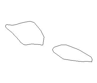
This South Pacific nation had an
unusual 4th of July in 1892.
1. What is the country?
2. What changed?
3. What is the only other occasion in
history when a similar change
occurred?
|
First You Have to Know Where Samoa Is Located
|