| XXX |
| XXX |
| House in the Lower Ninth Ward, New Orleans, LA April 25, 2006 Note the shingles missing from the roof where the storm surge took them away. Also note the brown lines across the front of the house where the water line stopped for a while when |
| XXX |
| Interior of a flooded house in the Lower Ninth Ward New Orleans, LA April 25, 2006 copyright Colleen Fitzpatrick |
| XXX |
| Interior of a flooded house in the Lower Ninth Ward New Orleans, LA April 25, 2006 copyright Colleen Fitzpatrick |
| XXX |
| Typical street in the Lower Ninth Ward, New Orleans, LA April 25, 2006 copyright Colleen Fitzpatrick |
quadrant (containing the strongest winds) was forecast to be 28 feet (8.5 m),
emergency management officials in New Orleans feared that the storm surge could go
over the tops of levees protecting the city, causing major flooding.
At a news conference at 10 am on August 28, shortly after Katrina was upgraded to a
Category 5 storm, New Orleans mayor Ray Nagin ordered the first-ever mandatory
evacuation of the city, calling Katrina "a storm that most of us have long feared." The
city government also established several "refuges of last resort" for citizens who could
not leave the city, including the massive Louisiana Superdome, which sheltered
approximately 26,000 people and provided them with food and water for several days
as the storm came ashore.
As the eye of Hurricane Katrina swept to the northeast, it subjected the city to hurricane
conditions for hours. Although power failures prevented accurate measurement of wind
speeds in New Orleans, there were a few measurements of hurricane-force winds.
From this the NHC concluded that it is likely that much of the city experienced
sustained winds of Category 1 or Category 2 strength.
Katrina's storm surge led to 53 levee breaches in the federally built levee system
protecting metro New Orleans and the failure of the 40 Arpent Canal levee. Nearly
| XXX |
| XXX |
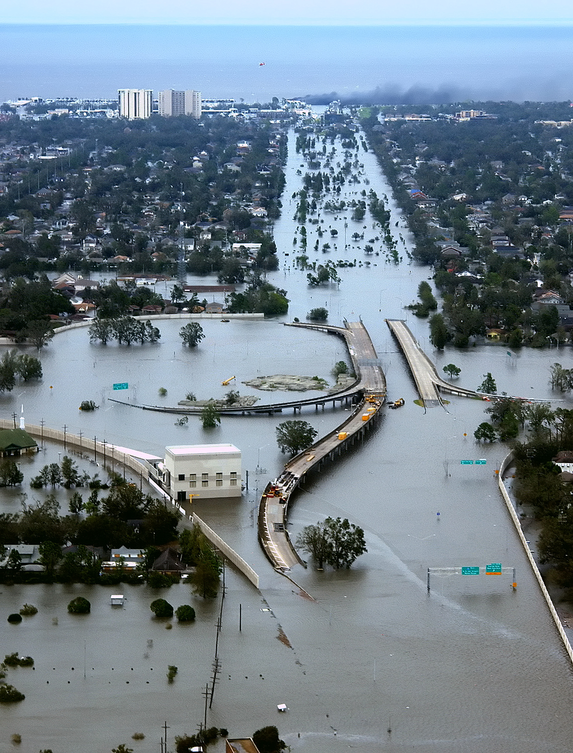
| New Orleans, Louisiana in the aftermath of Hurricane Katrina (2005:08:29 17:24:22), showing Interstate 10 at West End Boulevard, looking towards Lake Pontchartrain. The 17th Street Canal is just beyond the left edge of the image. The breach in the levee of that canal was responsible for much of the flooding of the city in the hours after the hurricane. In the foreground, the intersection is the juncture of I-10, running from the bottom of the photo and curving |
| XXX |
| Hurricane Katrina |
| ********** |

| If you have a picture you'd like us to feature a picture in a future quiz, please email it to us at CFitzp@aol.com. If we use it, you will receive a free analysis of your picture. You will also receive a free Forensic Genealogy CD or a 10% discount towards the purchase of the Forensic Genealogy book. |


| If you enjoy our quizzes, don't forget to order our books! Click here. |
!-- Start Quantcast tag -->
| Quiz #402 Results |
| Answer to Quiz #402 - June 30, 2013 |
| ********** |
|

| Congratulations to Our Winners! Grace Hertz & Mary Turner - "Team Fletcher" Mike Dalton Carol Farrant Donna Jolley Carol Stansell Katie Guertin Arthur Hartwell Marcelle Comeau Gus Marsh Annette McLane Barbara Cangiamilla Margaret Waterman Tom Collins Janice M. Sellers W. David Samuelson Elaine C. Hebert Jim Kiser Suzan Farris Lisa Moskowitz Carol Stansell Margaret Paxton Kelly Fetherlin Joyce Veness Skip Murray Margaret Lanoue |
|
| ********** |
| ********** |
|

| Path of storm. www1.ncdc.noaa... |


| Satellite view of landfall. For an animation, see www.ncdc.noaa.gov/extremeevents |

| Infrared image of landfall. For an animation, see www.ncdc.noaa.gov/extremeevents |
| Hurricane Katrina en.wikipedia.org/wiki/Hurricane_Katrina |
Hurricane Katrina was the deadliest and
most destructive Atlantic tropical cyclone
of the 2005 Atlantic hurricane season. It
was the costliest natural disaster, as well
as one of the five deadliest hurricanes, in
the history of the United States. Among
recorded Atlantic hurricanes, it was the
sixth strongest overall. At least 1,833
people died in the hurricane and
subsequent floods, making it the deadliest
US hurricane since the 1928 Okeechobee
hurricane; total property damage was
estimated at $81 billion (2005 USD),
nearly triple the damage brought by
Hurricane Andrew in 1992.
Hurricane Katrina formed over the
Bahamas on August 23, 2005 and crossed
southern Florida as a moderate Category 1
hurricane, causing some deaths and
flooding there before strengthening rapidly
in the Gulf of Mexico. The hurricane
strengthened to a Category 5 hurricane
over the warm Gulf water, but weakened
before making its second landfall as a
Category 3 hurricane on the morning of
Monday, August 29 in southeast
Louisiana. It caused severe destruction
along the Gulf coast from central Florida
to Texas, much of it due to the storm
surge. The most significant number of
deaths occurred in New Orleans,
Louisiana, which flooded as the levee
system catastrophically failed, in many
cases hours after the storm had moved
inland. Eventually 80% of the city and
large tracts of neighboring parishes
became flooded, and the floodwaters
lingered for weeks. However, the worst
property damage occurred in coastal
areas, such as all Mississippi beachfront
towns, which were flooded over 90% in
hours, as boats and casino barges rammed
buildings, pushing cars and houses inland,
with waters reaching 6–12 miles (10–19
km) from the beach.
The hurricane surge protection failures in
New Orleans are considered the worst
civil engineering disasters in U.S. history
and prompted a lawsuit against the U.S. Army Corps of Engineers (USACE), the
designers and builders of the levee system as mandated by the Flood Control Act of
1965. Responsibility for the failures and flooding was laid squarely on the Army Corps
in January 2008 by Judge Stanwood Duval, U.S. District Court, but the federal agency
could not be held financially liable due to sovereign immunity in the Flood Control Act
of 1928. There was also an investigation of the responses from federal, state and local
governments, resulting in the resignation of Federal Emergency Management Agency
(FEMA) director Michael D. Brown, and of New Orleans Police Department (NOPD)
Superintendent Eddie Compass.
Several agencies including the United States Coast Guard (USCG), National Hurricane
Center (NHC), and National Weather Service (NWS) were commended for their
actions. They provided accurate hurricane weather tracking forecasts with sufficient
lead time.
By August 26, the possibility of unprecedented cataclysm was already being
considered. Many of the computer models had shifted the potential path of Katrina 150

miles (240 km) westward from the
Florida Panhandle, putting the city of
New Orleans directly in the center of
their track probabilities; the chances of a
direct hit were forecast at 17%, with
strike probability rising to 29% by August
28. This scenario was considered a
potential catastrophe because some parts
of New Orleans and the metro area are
below sea level. Since the storm surge
produced by the hurricane's right-front

| upload.wikimedia.org/wikipedia.... West End Blvd near the Quizmaster General's family home in New Orleans. |
| out of the photo to the left, with the western end of I-610, which extends off the photo from the center right, and the West End entrance/exit from I-10. The block shaped building at center left front is a pumping station, one of those used to pump water from heavy rains off city streets in more normal times. The far eastern end of Veterans Memorial Boulevard is seen just back from the interchange extending to the left. The view looks north toward Lake Pontchartrain. The stretch of ground with no buildings from the Interchange to the lake is Pontchartrain Blvd. (on the left) and West End Blvd. (on the right), with a linear park (formerly the route of the New Basin Canal) between them. Smoke can be seen rising near the lake, probably from the burning of the Southern Yacht Club building. This photo provided by the U.S. Coast Guard shows flooded roadways as the Coast Guard conducted initial Hurricane Katrina damage assessment overflights of New Orleans, Monday Aug. 29, 2005. This image was selected as picture of the day on the English Wikipedia for August 29, 2008. |
every levee in metro New Orleans was
breached as Hurricane Katrina passed just
east of the city limits. Failures occurred in
New Orleans and surrounding communities,
especially St. Bernard Parish. The
Mississippi River Gulf Outlet (MR-GO)
breached its levees in approximately 20
places, flooding much of east New Orleans,
most of Saint Bernard Parish and the East
Bank of Plaquemines Parish. The major
levee breaches in the city included breaches
at the 17th Street Canal levee, the London
Avenue Canal, and the wide, navigable
Industrial Canal, which left approximately
80% of the city flooded.
Most of the major roads traveling into and out of the city were damaged. The only
routes out of the city were the westbound Crescent City Connection and the Huey P.
Long Bridge, as large portions of the I-10 Twin Span Bridge traveling eastbound
towards Slidell, Louisiana had collapsed. Both the Lake Pontchartrain Causeway and the
Crescent City Connection only carried emergency traffic.
On August 29, at 7:40 am CDT, it was reported that most of the windows on the north
side of the Hyatt Regency New Orleans had been blown out, and many other high rise
buildings had extensive window damage. The Hyatt was the most severely damaged
hotel in the city, with beds reported to be flying out of the windows. Insulation tubes
were exposed as the hotel's glass exterior was completely sheared off.
The Superdome, which was sheltering many people who had not evacuated, sustained
significant damage. Two sections of the Superdome's roof were compromised and the
dome's waterproof membrane had essentially been peeled off. Louis Armstrong New
Orleans International Airport was closed before the storm but did not flood. On August
30, it was reopened to humanitarian and rescue operations. Limited commercial
passenger service resumed at the airport on September 13 and regular carrier operations
| ********** |


| they were draining the city. It stained the brick. Copyright Colleen Fitzpatrick |

resumed in early October.
Levee breaches in New Orleans also
caused a significant amount of deaths,
with over 700 bodies recovered in New
Orleans by October 23, 2005. Some
survivors and evacuees reported seeing
dead bodies lying in city streets and
floating in still-flooded sections, especially
in the east of the city. the advanced state
of decomposition of many corpses, some
of which were left in the water or sun for
days before being collected, hindered
efforts by coroners to identify many of the dead.
The first deaths reported from the city were reported shortly before midnight on
August 28, as three nursing home patients died during an evacuation to Baton Rouge,
most likely from dehydration. While there were also early reports of fatalities amid
mayhem at the Superdome, only six deaths were confirmed there, with four of these
originating from natural causes, one from a drug overdose, and one a suicide. At the
Convention Center, four bodies were recovered. One of the four is believed to be the
result of a homicide.
There is evidence that many prisoners were abandoned in their cells during the storm,
while the guards sought shelter. Hundreds of prisoners were later registered as
"unaccounted for".
A June 2007 report released by the American Society of Civil Engineers states that the
failures of the locally built and federally funded levees in New Orleans were found to be
primarily the result of system design flaws. The US Army Corps of Engineers who by
federal mandate is responsible for the conception, design and construction of the
region's flood-control system failed to pay sufficient attention to public safety.
According to modeling and field observations by a team from Louisiana State

University, the Mississippi River Gulf
Outlet (MRGO), a 200-meter-wide
(660-foot-wide) canal designed to provide
a shortcut from New Orleans to the Gulf
of Mexico, helped provide a funnel for the
storm surge, making it 20% higher and
100%-200% faster as it crashed into the
city. St. Bernard Parish, one of the more
devastated areas, lies just south of the
MRGO. The Corps of Engineers disputes
this causality and maintains Katrina would
have overwhelmed the levees with or
without the contributing effect of the
MRGO. The water flowing west from the storm surge was perpendicular to MRGO,
and thus the canal had a negligible effect.
There was unfounded speculation made by residents concerning a possible planned
levee breach. Many references are made to the 1927 flood in which a levee was
breached south of New Orleans in order to divert floodwater to the Gulf of Mexico.
Recently,[when?] the U.S. Fish and Wildlife Service and the Nature Conservancy have
developed a floodplain reconnection project in which the Ouachita River would be
connected to its floodplain and the Gulf of Mexico. A breach in the levee[vague] caused
the water level downstream to drop six inches (152 mm) in a previous event in the early
1990s. Both cases show the many benefits of allowing the river to run its
course.[improper synthesis?]
On April 5, 2006, months after independent investigators had demonstrated that levee
failures were not caused by natural forces beyond intended design strength, Lieutenant
General Carl Strock, Chief of Engineers and Commander of the Corps of Engineers,
testified before the United States Senate Subcommittee on Energy and Water that "We
have now concluded we had problems with the design of the structure." He also
testified that the U.S. Army Corps of Engineers did not know of this mechanism of
failure prior to August 29, 2005. The claim of ignorance is refuted, however, by the
National Science Foundation investigators hired by the Corps of Engineers, who point
to a 1986 study by the Corps itself that such separations were possible in the I-wall
design.
Many of the levees have been reconstructed since the time of Katrina. In reconstructing
them, precautions were taken to bring the levees up to modern building code standards
and to ensure their safety. For example, in every situation possible, the Corps of
Engineers replaced I-walls with T-walls. T-walls have a horizontal concrete base that
protects against soil erosion underneath the floodwalls.
However, there are funding battles over the remaining levee improvements. In February
2008, the Bush administration requested that the state of Louisiana pay about $1.5

Floodwaters pour through a levee along
Inner Harbor Navigational Canal near
downtown New Orleans on Aug. 30,
2005, a day after Katrina passed
through the city. www.gbooza.com/photo..
Inner Harbor Navigational Canal near
downtown New Orleans on Aug. 30,
2005, a day after Katrina passed
through the city. www.gbooza.com/photo..
billion of an estimated $7.2 billion for
Corps of Engineers level work (in
accordance with the principles of local
cost sharing required by Congress as early
as the Flood Control Act of 1928), a
proposal which angered many Louisiana
leaders.
On May 2, 2008, Louisiana Gov. Bobby
Jindal used a speech to The National Press
Club to request that President Bush free up
money to complete work on Louisiana's
levees. Bush promised to include the levee
funding in his 2009 budget, but rejected the
idea of including the funding in a war bill,
which would pass sooner.